
I’m on a motorcycle trip that I will detail later on my Geek on a Harley blog. I’m heading to Edmonton and the highway through Jasper has re-opened recently. I found out last night before starting on today’s ride that limited services have become available in the townsite, so I decided to stop for fuel there.
I have a few observations from my brief visit to the site of July’s tragic forest fire.
Looking from the fringe
I should note that I didn’t do any kind of ‘disaster tourism’. I did notice a couple of big tour buses driving around, so maybe that’s a thing. Instead my observations were made from the side of the opened main road. The damaged areas of the town are ‘out of bounds’ with barricades, and I didn’t gawk around or try to get any special access.
Selective devastation of the town
I had built up an image of near complete devastation for the townsite itself based on news reports. Actually driving through the town gave me a different perspective. The damage was incredibly inconsisent and strange.
Most of the damage seems to have occurred on the west end of the townsite. Badly damaged buildings have largely been demolished now which in a sense is a good thing: it suggests that reconstruction is going to get underway quickly.
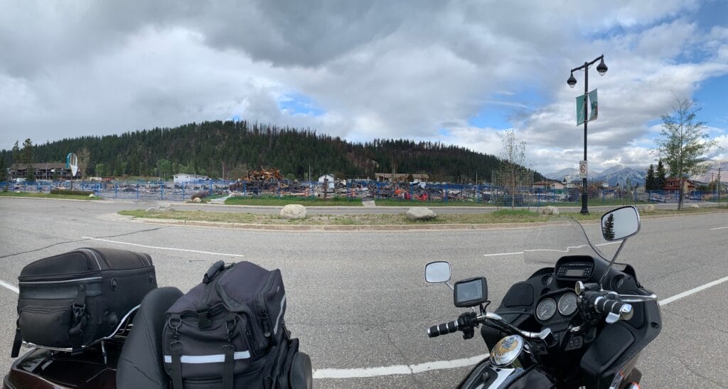
The East end of the townsite seems largely untouched. This is where I think most of the newer structures are, and it appeared that at least one hotel is open there. There are at least two open gas stations, some restaurants, and a number of shops open.
The gas station I stopped at, a Shell on the North side of the main road, was completely untouched. Barely 100 metres away on the South side was a Petro Canada station that is a complete write off.

The area around the townsite
I arrived in Jasper from the West which led to one rather surreal aspect of the damage: everything looked ‘fine’ from that side. There was no sign of a forest fire: no burned trees, just the usual greenery I’m used to seeing around Jasper townsite until I arrived at the turnoff to the town. At that point there was evidence of burn-damaged trees to the south.
Highway 16 on the East side of the townsite was a different story. There it was obvious the fire had burned for miles in that direction: scorched and burned trees were evident on the North side of the highway as far as the eye could see. But a look to the south side of the highway gave the impression that things were ‘normal’: green forest without any obvious signs of fire damage.
There has been rain recently as well, so the air was quite clear. Other than some odd smells around the townsite itself it smelled quite normal.
Conclusion
A lot of Jasper townsite’s historical structures have clearly been lost, and the tragedy for local residents and business owners will likely take years to get over. The town shows good signs, however, of already working to rebuild.
It is less clear to me how badly the local forest has been harmed. From my naive place driving along the highway, the forest damage looks fairly contained to the North and East of the townsite. There is still a lot of healthy-looking forest to the South-East, but I understand that a lot of damage was done along the North end of the Icefields Parkway straight south from the township.
One small positive note was that I saw several elk just outside the Jasper townsite, nibbling grass and bush along the south side of the freeway. It was nice to know that they are returning to the area.
Thanks for the eyes on perspective.
You are welcome, Liz.
As I say, it felt a bit odd: if I faced certain directions it still looked like good old Jasper town. Turn the other way and it looked like a disaster zone. Hopefully everyone who lost a house gets re-homed, and fingers crossed that they do a decent job ‘restoring’ the way things used to look.
Pingback: Road trip 2024: to Edmonton - Geek on a Harley